Archive Record
Images
Metadata
Catalog Number |
2003.254.005 |
Collection |
Pishel, Velma |
Object Name |
Map |
Date |
1950 |
Scope & Content |
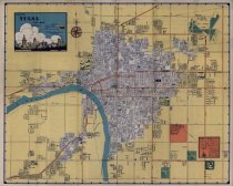
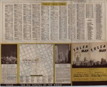
City map of Tulsa, OK, measuring 23.75" x 19" and created in 1950 by J. Foster Ashburn of Tulsa, OK as a promotional item for National Bank of Tulsa. In addition to a downtown area map of Tulsa and a highlighted community of Alsuma, the map provides a street guide index and highlights points of interest in area. |
Search Terms |
Alsuma, OK downtown Tulsa maps National Bank of Tulsa Tulsa maps |