Archive Record
Images
Metadata
Catalog Number |
2024.045.037 |
Collection |
New, James Richard |
Object Name |
Map |
Date |
1958 |
Scope & Content |
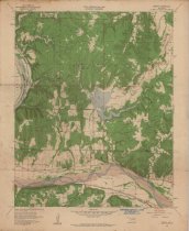
Topography map measuring 21.75" x 27" and produced in 1958 by the United States Department of the Interior Geological Survey showing the Oklahoma Wekiwa Quadrangle. The map includes the area from Township 21 North on the north, Township 19 North on the South, Range 10 East on the west, and Range 11 East on the east. The lower one-third of the map shows the Arkansas River running horizontally within Tulsa County. The maps shows the boundary line between Tulsa County and the Osage Indian Reservation. The top two-thirds of the map shows a portion of Osage County, OK, including Black Dog, Phillips Lake, Shell Lake, and Anderson School The map also includes landmarks such as towns, churches, refineries, oil wells, and oilfields. The lower margin of the map contains a stamp for Consolidated Geophysical Surveys of Tulsa, OK. |
Search Terms |
Consolidated Geophysical Surveys maps Missouri, Kansas & Texas "M. K. & T." Railway oil & gas wells oilfields Osage County, OK Osage Nation petroleum industry Saint Louis & San Francisco "Frisco" Railway Sand Springs, OK topographical maps Tulsa County, OK Wekiwa, OK |