Archive Record
Images
Metadata
Catalog Number |
2024.045.049 |
Collection |
New, James Richard |
Object Name |
Map |
Date |
1967 |
Scope & Content |
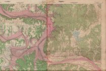
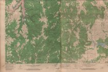
Topography map measuring 40" x 49" and produced in 1959 and photorevised in 1967 by the United States Department of the Interior Geological Survey and the Tulsa Metropolitan Area Planning Commission. The map shows the Oklahoma Wekiwa Quadrangle, and includes the area from Township 21 North on the north, Township 18 North on the South, Range 9 East on the west, and Range 11 East on the east. The Arkansas River is visible running horizontally through the map. Keysone Dam is delineated in the center of the map. A portion of Sand Springs, OK is visible at the far right. The map also delineates oil fields, oil wells, oil pipelines, schools, churches, county lines, the bounadry line of the Osage Reservation, creeks, lakes, and railroad tracks. |
Search Terms |
Arkansas River Cimarron River Creek County, OK Keystone Dam Keystone Lake Lake Sahoma Mannford, OK maps oil & gas wells oilfields Osage County, OK Osage Nation Pawnee County, OK petroleum industry Phillips Lake Prattville, OK Red Fork, OK Saint Louis & San Francisco "Frisco" Railway Sand Springs, OK Shell Lake topographical maps Tulsa County, OK |
People |
Horkey, William B. |