Archive Record
Images
Metadata
Catalog Number |
2024.045.028 |
Collection |
New, James Richard |
Object Name |
Map |
Date |
1978 |
Scope & Content |
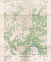
Topography map measuring 21.75" x 27" and produced in 1978 by the United States Department of the Interior Geological Survey showing the Oklahoma Bug Creek Quadrangle. The map includes the area from Township 23 North on the north, Township 22 North on the South, Range 6 East on the west, and Range 7 East on the east. Bug Creek Camp is visible near the center of the map in Osage County, OK. The Arkansas River is visible near the lower margin, which forms the boundary between Osage County and Pawnee County. The map shows the locations of numerous oilfields, oil wells, and pipelines. |
Search Terms |
Arkansas River maps oil & gas wells oilfields Osage County, OK Pawnee County, OK petroleum industry topographical maps |