Archive Record
Images
Metadata
Catalog Number |
2022.207.011C |
Collection |
Hart, Donna L. |
Object Name |
Map |
Date |
1980 |
Scope & Content |
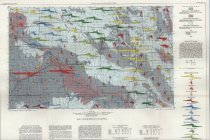
Hydrological map measuring 36.5" x 33" published by the Oklahoma Geological Survey in cooperation of the United States Geological Survey under the direction of Charles J. Mankin. This map is entitled "Reconnaissance of the Water Resources of the Woodward Quadrangle, Northwestern Oklahoma" and was created by Robert B. Morton. It was prepared by International Aerial Mapping Company, located in San Antonio, TX, and printed by Williams & Heintz Map Corporation, located in Capitol Heights, MD, in 1980. The map focuses on the region's available water resources and use. |
Search Terms |
geologists & geology maps Oklahoma Oklahoma Geological Survey topographical maps |