Archive Record
Images
Metadata
Catalog Number |
2019.132.003 |
Collection |
Campbell, Gayle D. |
Object Name |
Map |
Date |
circa 1928 |
Scope & Content |
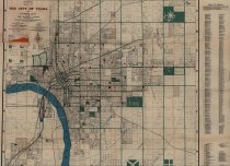
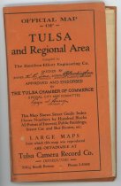
Map of Tulsa, OK and regional area measuring 33.75" x 28" compiled by Hamilton-Elliot Engineering Company, circa 1928. The Special City Map Committee of the Tulsa Chamber of Commerce approved and endorsed its production. The map delineates the area from 36th Street North to 51st Street on the south, and from 41st Street West to Memorial Drive on the east. In addition to city streets and highways, the map also shows bus lines, street car lines, parks, cemeteries, airports, golf courses, and schools. The map details several airports including the following: Tulsa Municipal Airport, McIntyre Airport, Garland Airport, and North American Air Lines, Inc. Other points of interest include the Tulsa County Club and Kennedy Golf Club at the northwest, and the County Farm for the poor and indigent on 51st Street on the south. The right margin contains a street index. The margin also contains a list of public schools, parochial schools, private schools, buildings, and churches that are each numbered and correspond to a number on the map image. |
Search Terms |
buses & bus lines cemeteries Garland Airport golfers & golf courses Kennedy Golf Club maps McIntyre Airport North American Air Lines, Inc. parks schools streetcars & trolleys Tulsa Chamber of Commerce Tulsa Country Club Tulsa Municipal Airport |