Archive Record
Images
Metadata
Catalog Number |
2024.045.036 |
Collection |
New, James Richard |
Object Name |
Map |
Date |
1973 |
Scope & Content |
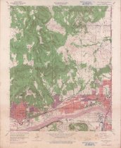
Topography map measuring 21.75" x 27" and produced in 1956 and revised in 1973 by the United States Department of the Interior Geological Survey showing the Oklahoma Sand Springs Quadrangle. The map includes the area from Township 20 North on the north, Township 19 North on the South, Range 11 East on the west, and Range 12 East on the east. The lower one-third of the map shows the Arkansas River running horizontally. Sand Springs in Tulsa County, OK, is visible at the far left. The map also shows Red Fork, West Tulsa and the western edge of Tulsa, all in Tulsa County, OK. The top two-thirds of the map shows a portion of Osage County, OK. The map includes landmarks such as schools, churches, refineries, oil wells, and oilfields. |
Search Terms |
maps Missouri, Kansas & Texas "M. K. & T." Railway oil & gas wells oilfields Osage County, OK petroleum industry refineries Saint Louis & San Francisco "Frisco" Railway Sand Springs, OK topographical maps Tulsa County, OK |