Archive Record
Images
Metadata
Catalog Number |
2024.045.061 |
Collection |
New, James Richard |
Object Name |
Map |
Date |
03/31/1968 |
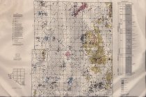
Scope & Content |
Subsurface geologic structure map showing the top of the Oswego Lime (Fort Scott limestone), the producing beds in oil and gas wells, and the deepest rocks penetrated in dry holes, as of March 31, 1968, for Townships 20 and 21 North, Ranges 11 and 12 East, in Osage County, OK. The right margin includes a columnar section of the of the types of rocks encountered in drilling. The map base was compiled from General Land Office surveys. Oil and gas well information was compiled from maps of the Osage Indian Agency. The map was copyrighted in 1968 by the Osage Tribe of Indians. |
Search Terms |
geologists & geology maps oil & gas wells Osage County, OK Osage Nation petroleum industry |