Archive Record
Images
Metadata
Catalog Number |
2021.001.201 |
Object Name |
Plat |
Date |
1923 |
Scope & Content |
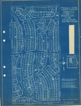
Plat map measuring 8.5" x 11" and delineating the streets and town lots of Terwilleger Heights Addition to Tulsa, Tulsa County, OK, located in Section 18, Township 19 North, Range 13 East. The original plat for Terwilleger Heights Addition was filed May 21, 1923. This print contains a copyright date of 1923 by A. T. Thorne. |
Search Terms |
22nd Place 22nd Street 24th Street 26th Street bridle paths maps plat maps South St. Louis Avenue South Trenton Avenue South Troost Avenue South Utica Avenue Terwilleger Boulevard Terwilleger Heights Addition |