Archive Record
Images
Metadata
Catalog Number |
2012.086.146 |
Object Name |
Map |
Date |
1965 |
Scope & Content |
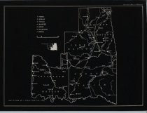
Photocopy of a map from the 1965 publication "Historical Atlas of Oklahoma," by John W. Morris and Charles R. Goins entitled "Indian Territory, 1889." The map delineates the boundaries for the following tribal lands: Peoria, Quapaw, Ottawa, Shawnee, Modoc, Wyandotte, Seneca, Cherokee, Creek, Choctaw, Chickasaw, and Seminole. The map also includes rivers and railroads. |
Search Terms |
Cherokee Nation Chickasaw Nation Choctaw Nation Creek Nation maps Oklahoma maps railroads rivers Seminole Nation |