Archive Record
Images
Metadata
Catalog Number |
2024.045.038 |
Collection |
New, James Richard |
Object Name |
Map |
Date |
1966 |
Scope & Content |
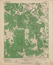
Topography map measuring 21.75" x 27" and produced in 1966 by the United States Department of the Interior Geological Survey showing the Oklahoma Avant Quadrangle. The map includes the area from Township 23 North on the north, Township 22 North on the South, Range 11 East on the west, and Range 12 East on the east. The top portion of the map shows the town of Avant, OK on Bird Creek. The lower portion of the maps shows the Javine Oil Field. Other oil fields identified include Skiatook Oil Field and West Avant Oil Field. The map also includes landmarks such as churches, oil pipelines, and railroads. The lower margin of the map contains a stamp for Consolidated Geophysical Surveys of Tulsa, OK. |
Search Terms |
Avant, OK Bird Creek Consolidated Geophysical Surveys Javine Oil Field maps Midland Valley Railroad oil & gas wells oilfields Osage County, OK Osage Nation petroleum industry pipelines Skiatook Oil Field topographical maps West Avant Oil Field |