Archive Record
Images
Metadata
Catalog Number |
2024.045.022 |
Collection |
New, James Richard |
Object Name |
Map |
Date |
1966 |
Scope & Content |
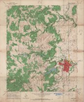
Topography map measuring 21.75" x 27" and produced in 1966 by the United States Department of the Interior Geological Survey showing the Oklahoma Hominy Quadrangle. The map includes the area from Township 23 North on the north, Township 22 North on the South, Range 8 East on the west, and Range 9 East on the east. The map shows the location of Hominy in Osage County, OK in red at the lower right. The map also shows the Hominy Oilfield, pipelines, oil storage tanks, and the Missouri, Kansas & Texas "M. K. & T." Railway. The lower margin of the map contains the stamp of Consolidated Geophysical Surveys of Tulsa, OK. |
Search Terms |
Consolidated Geophysical Surveys Hominy, OK maps Missouri, Kansas & Texas "M. K. & T." Railway oil & gas wells oilfields Osage County, OK petroleum industry topographical maps |