Archive Record
Images
Metadata
Catalog Number |
2024.045.075 |
Collection |
New, James Richard |
Object Name |
Map |
Date |
12/01/1970 |
Scope & Content |
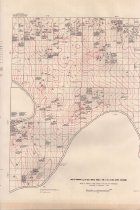
Subsurface geologic structure map showing the top of the Mississippian and producing oil and gas wells, as of December 1, 1970, for Townships 23-25 North, Ranges 4 and 5 East, in Osage County, OK. The map base was compiled from General Land Office surveys. Oil and gas well information was compiled from maps of the Osage Indian Agency. The map was copyrighted in 1970 by the Osage Tribe of Indians. |
Search Terms |
geologists & geology maps oil & gas wells Osage County, OK Osage Nation petroleum industry |