Archive Record
Images
Metadata
Catalog Number |
2024.045.025 |
Collection |
New, James Richard |
Object Name |
Map |
Date |
1978 |
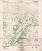
Scope & Content |
Topography map measuring 21.75" x 27" and produced in 1978 by the United States Department of the Interior Geological Survey showing the Doga Creek Quadrangle. The map includes the area from Township 25 North on the north, Township 24 North on the South, Range 4 East on the west, and Range 5 East on the east. The center of the map shows the location of Doga Creek in Osage County, OK. The Arkansas River is visible running diagonally forming the border between Osage County and Pawnee County. The maps also includes various oilfields, oil wells, and quarries. Ralston Cemetery in Pawnee County is visible at the lower right. The lower margin of the map contains the stamp of Consolidated Geophysical Surveys of Tulsa, OK. |
Search Terms |
Arkansas River Consolidated Geophysical Surveys maps oil & gas wells oilfields Osage County, OK Pawnee County, OK petroleum industry topographical maps |