Archive Record
Images
Metadata
Catalog Number |
2024.045.018 |
Collection |
New, James Richard |
Object Name |
Map |
Date |
1949 |
Scope & Content |
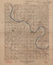
Topography map measuring 17" x 20.75" and produced by the United States Department of the Interior Geological Survey showing the Oklahoma Skedee Quadrangle. The map is the 1931 edition, reprinted in 1949. It includes the topography survey completed by W. B. Upton, Jr., S. B. O'Hara, and S. S. Evans in 1927 through 1929. The map includes the area from Township 23 North on the north, Township 21 North on the South, Range 5 East on the west, and Range 7 East on the east. The Arkansas River is shown running diagonally through the map, which serves as the border between Osage County and Pawnee County, OK. The community of Skedee, in Pawnee County, OK is shown near the left margin. The map also includes the locations of three railroads: Atchison, Topeka and Santa Fe Railway, Missouri, Kansas & Texas "M. K. & T." Railway, and Saint Louis & San Francisco "Frisco" Railway. |
Search Terms |
Arkansas River Atchison, Topeka and Santa Fe Railway maps Missouri, Kansas & Texas "M. K. & T." Railway oil & gas wells oilfields Osage County, OK Pawnee County, OK petroleum industry Saint Louis & San Francisco "Frisco" Railway Skedee, OK topographical maps |