Photo Record
Images
Metadata
Catalog Number |
2022.190.1411 |
Collection |
Hawks, Bob |
Object Name |
Negative, Sheet Film |
Date |
circa 1958 |
Photographer |
Hawks, Bob |
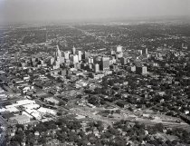
Description |
Black & white sheet film negative measuring 5" x 4" and depicting an aerial view of downtown Tulsa, OK, circa 1958. The camera view is toward the southeast. In the lower center of the photograph, Heavy Traffic Way, the Saint Louis & San Francisco "Frisco" Railway, and Sand Springs Railway tracks can be seen from left to right. In the lower left corner, West Archer Street is visible curving to match the east-west orientation of the newer residential streets. When the City of Tulsa streets were originally laid out in 1901, they ran parallel and perpendicular to the "Frisco" Railroad tracks. In 1920, Admiral Boulevard was established along an east-west axis that was at an angle to the original city layout. This is apparent in the photograph with the streets in the distance running at an angle to downtown Tulsa. |
Search Terms |
aerial images Archer Street downtown Tulsa Heavy Traffic Way Saint Louis & San Francisco "Frisco" Railway Sand Springs Railway Company Tulsa skylines |
Place |
Tulsa, OK |