Photo Record
Images
Metadata
Catalog Number |
2016.028.1240 |
Collection |
Hopkins, Howard |
Object Name |
Negative, Sheet Film |
Date |
05/06/1970 |
Studio |
Hopkins Photography Company |
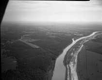
Description |
Black & white sheet film negative measuring 5" x 4" and depicting an aerial view of the radar cross section range operated by North American Rockwell, Inc on May 6, 1970. The range was located on company property adjacent to the Verdigris River, approximately eighteen miles east of Air Force Plant #3, also known as "Rockwell Building #1." |
Search Terms |
aerial images North American Rockwell, Inc. radar South Skelly Road Verdigris River |
Place |
Tulsa, OK |